Media contact: Michael Browne, Media Lead, No 765 Line, Inc. — press@no765line.org
Reproduce freely. This release, the maps, and the route data may be republished with credit to No 765 Line, Inc.
The first route maps for the proposed BECI 765 kV line leave out centerlines, tower locations, and easement boundaries; one published segment connects to nothing at all. No 765 Line has released the developer’s mapping data in open formats so the public can see exactly what was published, and what was not. The developer’s comment deadline is September 7.
SENECA, WIS., AUGUST 12, 2026 — When Wisconsin’s last comparable transmission project moved from first announcement to state application, landowners had a 37-month public information phase, including a final year devoted to one-on-one meetings with siting engineers. Midcontinent Grid Solutions (MGS) is attempting to compress that entire process for the proposed BECI 765,000-volt transmission line into roughly seven months: its first route maps appeared this month, letters are still arriving in mailboxes, its public comment deadline is September 7, and it has said it intends to file with the Public Service Commission of WisconsinThe state board that decides whether power lines get built. The application it reviews — a Certificate of Public Convenience and Necessity, or CPCN — opens the formal window where the public can comment and intervene. in February 2027.
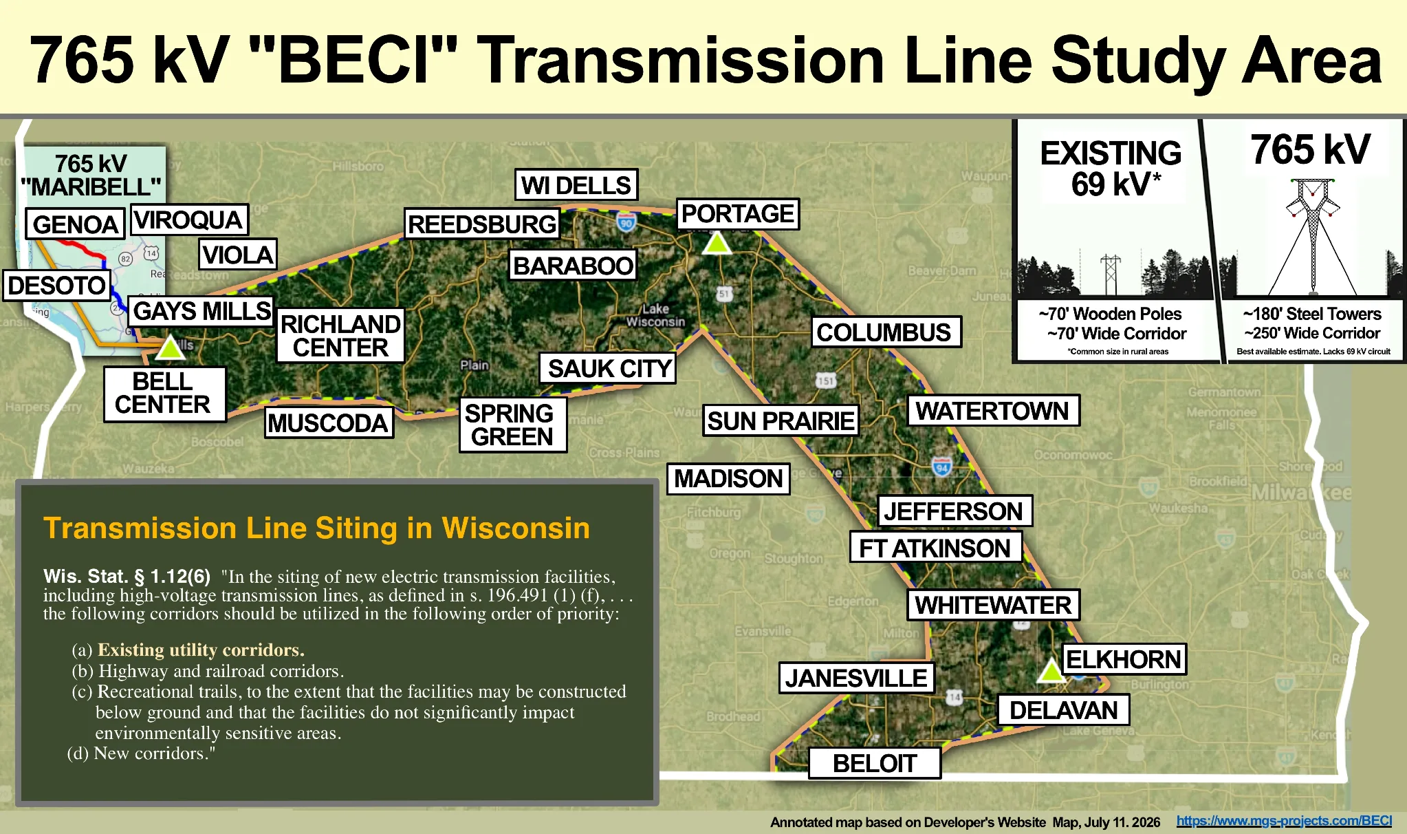
The maps landowners are being asked to comment on leave out the details the comment process exists to resolve. The 78 published “study segments” — blue lines across nine southern Wisconsin counties — include no centerlines, no easement boundaries drawn to scale, and no tower locations or heights. At least one published segment (the developer’s segment 30, between the Columbia and Sugar Creek connection points) connects to no other published segment and no identified connection point.
“Badger Coulee had a 37-month public information phase — not seven months,” said Rob Danielson, a Vernon County landowner and No 765 Line board member who intervened in that 2010s proceeding, speaking on the organization’s new podcast. “The final year was dedicated exclusively to one-on-one meetings with landowners to work out siting accommodations.” Wisconsin’s utilities have historically run those longer information phases voluntarily; no state law sets a minimum.
The line would run approximately 190 miles from Bell Center in Crawford County through Columbia County and south to the Illinois state line, with towers roughly 180 to 200 feet tall on easements approximately 250 feet wide, crossing parts of Crawford, Richland, Sauk, Columbia, Dodge, Dane, Jefferson, Rock, and Walworth Counties (developer’s published study area, mgs-projects.com/BECI).
“Landowners shouldn’t need to be map experts to find out whether a 200-foot tower is being studied for their back forty,” said Michael Browne, Media Lead for No 765 Line. “But even with one, these maps won’t tell you where the towers would stand, how wide the easement would be, or, in at least one case, how the line connects at all. We’ve published everything the developer released, in open formats, so the public can see exactly what is there and what is not.”
Source · MGS project website (study segments and study area, geometry captured August 2026) · Badger-Coulee public-information record, Wisconsin PSC
What residents can do now
No 765 Line encourages residents — whether or not a study segment crosses their property — to take three steps:
- Send MGS a written information request. The developer invites questions at Connect@MGSWisconsin.com. Landowners can request parcel-scale maps showing the proposed centerline on their own parcels, the easement width drawn to scale, construction areas and access roads, and the locations and heights of proposed towers — and bring a copy of the request to an open house. Guidance for landowners: no765line.org/landowners.
- Contact your state legislators. Residents can find their legislators at legis.wisconsin.gov and ask them to see that Wisconsin’s existing corridor-siting priorities (Wis. Stat. § 1.12(6)) are honored and that landowners receive the information — and the time — needed for meaningful input before the developer files its application.
- Show up. Attend the August 17 town hall or a developer open house August 24–27, and submit written comments to the developer by September 7.
The route data, released for public accountability
So that landowners, local officials, and newsrooms can verify all of this independently, No 765 Line has released the developer’s published route geometry in open formats: GeoJSON files of the 78 study segments, the nine-county study area, and the five identified connection points, plus a single KMZ file that opens directly in Google Earth. The geometry was captured verbatim from the developer’s own public project map in August 2026; every observation above, including segment 30’s missing connections, can be checked against the developer’s map using these files.
Complete route-data bundle — 78 study segments + study area + connection points, GeoJSON ×3 + Google Earth KMZ + provenance README
All files and attribution guidance: no765line.org/press-kit/ · by email from press@no765line.org
Source · Geometry captured verbatim from mgs-projects.com/BECI, August 2026. These are the developer’s preliminary study segments, not proposed or final routes.
A podcast on what landowners can do
In episode 1 of Not a Done Deal, the organization’s new podcast, Danielson walks through the information landowners can request in writing before September 7 — the same items missing from the published maps. Listen on Apple Podcasts or Spotify; no765line.org will carry every episode. His message to landowners along the segments: “This is not a done deal.”
Public events this month
Monday, August 17, 5:30 p.m. — 765 kV Town Hall, Retreat Sportsman’s Club, E3460 County Rd N, De Soto. A public conversation about the proposed MariBell 765 kV project — the separate line proposed by Dairyland Power Cooperative and GridLiance Heartland from Marion, Minnesota to Bell Center in Crawford County — and its potential impact on southwest Wisconsin. Hosted by the Coalition Against MariBell 765 and moderated by attorney Erik Olsen. Speakers include No 765 Line, Stop AI Power, Inc., state and local officials, community leaders, and subject-matter experts. Contact: coalition.against.maribell.765@gmail.com.
August 24–27 — MGS open houses on the BECI study segments. Richland and Crawford Counties (Aug. 24), Sauk and Columbia (Aug. 25), Jefferson and Dane/Dodge in Sun Prairie (Aug. 26), Walworth and Rock (Aug. 27). Each listing carries the venue, times, and what to bring: no765line.org/events. Written comments to the developer are due September 7.
MariBell and BECI are separate projects with separate developers and separate filing timelines; both are part of MISO’s Long-Range Transmission Plan Tranche 2.1 portfolio approved in December 2024 (~$21.8 billion; misoenergy.org).
# # #
About the organizations named in this release
Midcontinent Grid Solutions. Midcontinent Grid Solutions (MGS) was selected by MISO to build and maintain the BECI line. MGS pulls together the expertise and experience of Transource Energy — a joint venture of American Electric Power and Evergy — and Berkshire Hathaway Energy U.S. Transmission. mgs-projects.com/BECI
Midcontinent Independent System Operator. Midcontinent Independent System Operator (MISO) is the nonprofit that runs the electric grid and plans large power lines across 15 states, including Wisconsin. It plans which lines get built; state regulators must still approve them.
No 765 Line. No 765 Line, Inc. is a Wisconsin nonprofit comprised of citizens, businesses, and organizations that share concerns about the potential impact of two proposed 765 kV transmission lines planned to cross southern Wisconsin and beyond. no765line.org