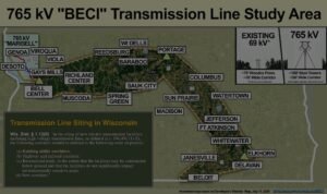
A 765,000-volt (765 kV) transmission line doesn’t cross empty ground. The proposed MariBell and BECI corridors through the Driftless would run across a working stretch of the Mississippi Flyway, over cold-water trout streams, above the karstFractured, water-soluble bedrock — limestone and dolomite — dissolved over time into an interconnected web of cracks, crevices, and caves. Water moves through it quickly, which is why karst aquifers are both productive and hard to protect. groundwater that feeds the region’s wells, and through the range of wildlife the federal government already protects.
Today we published a new page — Living systems in the path — with an interactive map at the center of it. It gathers what the public record already shows about the plants and animals along the route, and it shows that information at a deliberately coarse scale: enough to orient a first-time visitor and point the state’s review toward questions that need answering, without ever publishing the precise locations of rare or sensitive species.
What the map shows
The map draws on three public sources that anyone can check. From iNaturalist, more than two hundred research-grade bird species recorded in the corridor region. From eBird, 127 public birding hotspots the line and its alternate routes would cross or pass. From the U.S. Fish & Wildlife Service, the coarse federal zones for a protected bumble bee and the mussel-rich watersheds along the river reach.
Every bird observation on the map is binned to a grid roughly two kilometers on a side — counts only, no pinpoint locations. You can toggle any layer or pick a single species and watch where it has actually been seen. What you are looking at is not a campaign database; it is a plain-scale picture assembled from records scientists and birders have already made public.
Source · iNaturalist (species observations); eBird (birding hotspots); U.S. Fish & Wildlife Service (protected-species zones and mussel watersheds)
research-grade bird species recorded along the corridor — a living Mississippi flyway.
Source · iNaturalist, corridor regionpublic birding hotspots the line and its alternate routes would cross or pass.
Source · eBirdmussel-rich watersheds in the corridor — some holding up to six species.
Source · USFWS Midwest mussel hotspots (HUC8)Above ground: a living flyway
The corridor runs through the Mississippi Flyway, one of the continent’s great migration routes. One of the most-recorded birds in the corridor is the bald eagle — protected under the federal Bald and Golden Eagle Protection Act — with 162 sightings logged in the corridor region as of June 2026.
At a June 6 field day on restored land near Seneca, retired Wisconsin DNR biologist Mark Martin turned on a bird-identification app and, in a single afternoon, logged a list that included the cerulean warbler, a Wisconsin threatened species that breeds in the mature Driftless forest a cleared right-of-way would fragment. Martin was careful not to overstate the risk to songbirds — he said plainly he couldn’t put a number on it. His sharper concern was for heavy-bodied birds crossing the river, like swans and cranes, which can strike high lines, especially in fog. Some of those collisions, he noted, can be reduced with the right engineering; others can’t. We reported on that field day here.
Source · iNaturalist observation counts; Bald and Golden Eagle Protection Act; Mark Martin’s remarks at the June 6, 2026 field day (see our report)
Below ground: water you can’t see
Across nearly its whole length the corridor crosses classified cold-water trout streams — a defining feature of the Driftless, not an isolated stretch. Below them lies carbonate karst: fractured rock dissolved into an interconnected web of cracks and caves. A tower footing drilled into it can sit above a void no single test boring detects, and each boring is itself a potential path for surface contamination to reach an aquifer that can’t be flushed once it’s fouled.
That is not our claim to make alone. It is the concern a karst specialist from the Crawford Stewardship Project walked through, on the ground, at the same field day — that a single borehole at each tower tells you very little about what’s underneath it.
Source · WI DNR trout-stream classifications; WGNHS + USGS carbonate-karst mapping; Crawford Stewardship Project remarks at the June 6, 2026 field day (see our report)
Federally protected — already on the map
Four of the species along the route aren’t abstractions or judgment calls. Each is already recognized by the federal government, and each raises a question the state’s review will have to answer.
- The rusty patched bumble bee is federally endangered, and the corridor sits inside a U.S. Fish & Wildlife Service High-Potential Zone for it.
- The northern long-eared bat is federally endangered; clearing a forested right-of-way removes the roost habitat it depends on.
- The monarch butterfly was proposed for federal listing in 2024; it depends on milkweed, including the Wisconsin-endangered purple milkweed found at the edge of an existing easement in the corridor.
- Freshwater mussels — including federally endangered species documented in the Upper Mississippi, such as the Higgins eye pearlymussel — live in the river the line would cross, and the corridor crosses 14 watersheds that USFWS maps as mussel-rich.
Federal listing matters here. These aren’t species a project can treat as background — they’re recognized in federal law, and their documented presence in the corridor is one more question the review will have to weigh, not a detail the state’s review can set aside.
Source · U.S. Fish & Wildlife Service (species listings, RPBB High-Potential Zone, Midwest mussel richness/hotspots HUC8); Wisconsin DNR (purple milkweed listed Endangered)
Why this belongs before the PSC
None of this decides the case on its own — and we don’t claim it does. But the line’s fate runs through the Wisconsin Public Service CommissionThe Wisconsin PSC — the state board that decides whether power lines get built. Its CPCN proceeding is where the public can formally comment and intervene., which reviews a project’s effects on people and the environment as part of its permit decision. The developers are expected to file their CPCN applicationA Certificate of Public Convenience and Necessity — the construction permit the developers must win from the Wisconsin PSC before they can build. The CPCN case is where the public can formally weigh in. in fall 2026. A route drawn before these systems are studied, or a single test boring at each tower, doesn’t answer the questions the record needs answered — and the point of showing what’s here, now, is to make sure those questions get asked while the docket is open. Where the towers would finally stand is not fixed; the developers have said themselves that specific routes and localized effects can’t yet be answered. So we keep our own language hedged: this is where the line could go, and what it could cross.
A public MISO plan, built by companies that profit.
The line is part of MISOThe Midcontinent Independent System Operator — the nonprofit that runs the electric grid and plans large power lines across 15 states, including Wisconsin. It plans which lines get built; state regulators still have to approve them.‘s regional transmission plan (Tranche 2.1) — a publicly planned, cost-allocated project, not a private or “merchant” venture. What we question is who benefits: of the companies developing the two lines, only Dairyland Power Cooperative is member-owned. The rest are private firms earning a regulated return, and Wisconsin ratepayers would help pay.
Source · MISO Long-Range Transmission Plan (Tranche 2.1) cost allocationHow you can help — safely
The map above is built from observations like the ones you can make. Every bird, plant, and animal documented along the corridor strengthens the public record before the PSC — and there’s a right way to do it that keeps sensitive species safe.
Use iNaturalist or Merlin and eBird to log what you see — they identify the species for you, build a citable record, and automatically obscure the precise locations of sensitive ones. If you find something endangered or rare, report it to the Wisconsin DNR Natural Heritage Inventory, the official state record agencies rely on. And if there’s something significant on your land, tell us you’d like to connect — we’ll help you get it documented with the right experts, without ever publishing precise sensitive locations.
Our map shows only coarse, federally-published zones and publicly-mapped features. We do not publish the precise locations of rare or sensitive species — that information can be misused, so it stays out of public view and goes to regulators through the proper channels. Observations you make go to independent scientific and state databases, not to a campaign list.
Correction, September 13, 2026: an earlier version referred to the two separately proposed projects, MariBell and BECI, by a single compound name.